Saturday, June 29, 2013

Summer Ride Of The West

France may have its vineyards, and Rome its ancient ruins, but America is the undisputed wonderland of roads. Here in the Land of the Free, the open road has long been a symbol of independence, and all the more so on a motorcycle.

But where to begin?

In the continental United States alone there are hundreds of thousands of miles of blacktop and cement, an oblivion of open road panning to all compass points. Lets start with Million Dollar Highway. It is a breathtaking high-mountain road and a scenic, twisty, exciting motorcycle ride that links the historic Colorado mining towns of Durango, Silverton, Ouray and Ridgeway.

How the Million Dollar Highway got its name you wonder???

One story says the Million Dollar Highway got its name from the high cost of cutting the road through the treacherous Red Mountain Pass between Ouray and Silverton.

Another says the name comes from the gold and silver deposits still buried beneath the highway.


I love the names of western towns. Living in the West makes it fun to mention places like Laramie, Abilene, Dodge City or Cheyenne when recounting motorcycle trips. For example: “We stopped in Laramie on our way to the Medicine Bow Mountains.”

You don't hear too much of that on Long Island, New York.

So, just for its name alone, I was pumped to be traveling through the West toward Durango, Colorado.


But, the real reason for my excitement was that in Durango I'd connect with one of this country’s premier scenic routes -- the Million Dollar Highway.

Durango’s colorful history as a rough-and-tumble Colorado mining and railroad town includes floods, fires, avalanches and a deadly flu epidemic.

The Denver & Rio Grande Railway built the town in 1880 to service mining camps including Silverton, Telluride and Ouray some 60 to 70 miles north.

Freight trains along the line hauled gold- and silver-laden ore mined from the surrounding San Juan Mountains -- the youngest and most rugged mountains in the Rockies.

Today, the Durango & Silverton Narrow Gauge Railroad remains one of the areas greatest attractions.
But what attracted me to Durango was Route 550 -- best known as the Million Dollar Highway.

Similar to the railroad tracks that also head north out of town, Route 550 shadows the Animas River through breathtaking high mountain terrain while linking Durango to Silverton, Ouray and Ridgeway.
During the 1880s, laborers carved the original highway out of the mountains using pickaxes, shovels and dynamite. Today’s route generally follows the old roadbed.When building the highway in the 1880s, workers were often lowered by rope hundreds of feet down the steep canyon walls to carve a roadbed through the most inaccessible sections.
They’d bore dynamite holes then light extra long fuses that gave the crews above enough time to pull up their co-workers before each explosion.
Occasionally, however, some did not make it up in time.

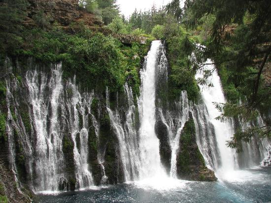
The highway from Silverton to Ouray through Red Mountain Pass is one of the most spectacular roads I’ve ever ridden on.
Many consider this 24-mile-long section the “real” Million Dollar Highway.
From Ouray, the Million Dollar Highway levels out and ends a few miles north in the green, scenic ranching area of Ridgeway.

If I didn't have a schedule to keep, I’d have turned around and ridden the 88 miles once again in the opposite direction.
Cruising along this winding ribbon of asphalt through these steep, rugged, forested mountains remains one of my most memorable motorcycle rides and a great destination.
                                                         .....TINY......

Thursday, June 27, 2013

ROAD TRIP!

This comes from Matt Gardener's (Owner Of LRS) blog  -    Gullible's Travels

Road trip with Dad - Enjoy it while you can!


’There are 3 stages in a man’s life: ‘My Daddy can whip your Daddy.’  ’Aw, Dad, you don’t know anything.’  ’My father used to say . . .”‘-Dwight McSmith


Not very many people get the opportunity to work for or with their parents, but I happen to be one of those who do. Some people might cringe at the thought of working with family, but in my honest opinion it has been one of the greatest blessings to be surrounded by people who love you day in and day out. Sure we don't always see eye to eye, but no one here is afraid to tell each other what we really think.


This week I have a great opportunity to get out on the road to go see some clients. Because I am  driving from my home town of Reno to Salt Lake City Utah, I opted to invite my dad to come with me and to relive one of my favorite road trips from my youth.


My dad is a huge rock hound who loves everything about the Nevada deserts, and many of my favorite memories of youth are traveling all over the state with my dad on hunting, hiking and outdoors adventures in the Silver State. This weekend we are traveling to SLC the long way around, rather than cruise up the I-80 ( which is the most boring road in the state) we have opted to take the Highway 50... also know as the loneliest highway in America. I have hundreds of memories traveling this road with my dad and brother, and it seems like all of them are very fond ones. It was this road on which I first heard the song "the Gambler", It was on this road that I heard my first sonic boom as Air-force Jets raced overhead. It was along this road that I visited Lehman's Caves and was inspired to explore the world.
Leahman's Caves


To some the desert might seem an isolated place, but to me an my dad its a world of adventure. The Nevada desert has been home to countless Indian wars, the pony express, outlaws, ghost towns, hidden caverns, snakes, and even the occasional Alien Abduction. On this trip we will be traveling over the same trail as famous mountain men like Kit Carson, Jacob Hamblin, and Jim Bridger. To some its just an ugly desert, but to me its a special place, even a holy place.

Nevada Pony Express Station


Besides all the adventure that this road has to offer, the thing I'm looking foreword to the most is simply spending some time with my dad. Any good route to travel will consist of three main ingredients: Adventure, Understanding and Friendship.

We never know when the time will come that we wont have our family there with us, when we will lose someone special, but the one thing within our control is the amount of time we choose to spend with those that we still have.

Happy Trails

- Gullible

Tuesday, June 25, 2013

The Secret National Park


The following comes from Matt Gardener's blog - Gullible's Travels


Matt is the owner of long ride shields and often contributes to the myths legends and tales blog. He recently went on a trip and discovered a national park that very few people know exists even those who live in the regional area (Even all of the LRS staff) knew very little about. Its not often you find a hidden gem.

Travel Tip #17: DITCH THAT GPS AND SHOOT FOR THE MOON!

Today's tip title seems fitting as there will be a super moon tonight!  (CLICK HERE FOR MORE INFO)

But the tip really has nothing to do with the moon, its more the stars and everything else that surrounds the moon that ends up being what we really take home.

You have heard the saying, shoot for the moon and you will hit the stars.... Well it applies to travel as well.

Today while on a 400+ mile motorcycle day trip I happened upon a gem in the sierras and the only reason we found it is because we bit off more than we could chew while trying to find a different way of getting from point A to B.

My buddy Jeremy and I decided on Thursday night that we would try to make it out on our motorcycles to a set of waterfalls we had heard about called MacArthur Burney Falls. We decided that we would take the long way around to get to our destination on some roads we found on the map but that would add some extra distance to the trip hoping to do some exploring in the process. We spent a few hour rambling about trying to find a road that was on the map but that had never even existed. Out of this chaos we found something new. We never even made it to the falls because we stumbled across a national park that neither of us had ever been to before.  In our efforts to make it to the falls we passed through Lassen Volcanic National Park and discovered a gem neither of us even knew existed. Each of us had lived in the area for 30 years and never thought to visit the place.

At the end of the day the consensus was that had we stuck to the beaten path and simply followed the GPS we would have never experienced this awesome day of riding!

So go ahead DITCH THAT GPS AND SHOOT FOR THE MOON! -  You will find something new amongst the stars that will make your journey even more complete.


Emerald lake view of Mt. Lassen


A man and his horse, I even wore cowboy boots! ( The ones I picked up on my last trip to Nashville)
Emerald Lake


The amazing winding road headed for the top of the pass.


Jeremy at the Mt. Lassen visitor center


This little table shows all the volcanos in the area and describes how the earths shape was formed.


Random movie fact of the day!

DID YOU KNOW THAT.......

Saturday, June 22, 2013

Travel Tip #17: DITCH THAT GPS AND SHOOT FOR THE MOON!

Today's tip title seems fitting as there will be a super moon tonight!  (CLICK HERE FOR MORE INFO)

But the tip really has nothing to do with the moon, its more the stars and everything else that surrounds the moon that ends up being what we really take home.

You have heard the saying, shoot for the moon and you will hit the stars.... Well it applies to travel as well.

Today while on a 400+ mile motorcycle day trip I happened upon a gem in the sierras and the only reason we found it is because we bit off more than we could chew while trying to find a different way of getting from point A to B.

My buddy Jeremy and I decided on Thursday night that we would try to make it out on our motorcycles to a set of waterfalls we had heard about called MacArthur Burney Falls. We decided that we would take the long way around to get to our destination on some roads we found on the map but that would add some extra distance to the trip hoping to do some exploring in the process. We spent a few hour rambling about trying to find a road that was on the map but that had never even existed. Out of this chaos we found something new. We never even made it to the falls because we stumbled across a national park that neither of us had ever been to before.  In our efforts to make it to the falls we passed through Lassen Volcanic National Park and discovered a gem neither of us even knew existed. Each of us had lived in the area for 30 years and never thought to visit the place.

At the end of the day the consensus was that had we stuck to the beaten path and simply followed the GPS we would have never experienced this awesome day of riding!

So go ahead DITCH THAT GPS AND SHOOT FOR THE MOON! -  You will find something new amongst the stars that will make your journey even more complete. 


Emerald lake view of Mt. Lassen


A man and his horse, I even wore cowboy boots! ( The ones I picked up on my last trip to Nashville)
Emerald Lake


The amazing winding road headed for the top of the pass.


Jeremy at the Mt. Lassen visitor center


This little table shows all the volcanos in the area and describes how the earths shape was formed.


Friday, June 21, 2013

Day Trippin! - A DAY ALL TO MYSELF!

So coming up in a few weeks I will be on the road for three weeks strait. First Utah, Then Wisconsin, Chicago, Detroit and finally LA.

However between now and the 4th of july I am taking it easy. But that doesn't mean I'm not going anywhere - NO SIR -  I can't seem to stay in one place for long..... bad for my reputation and all.

Tomorrow I have a day trip planned with a buddy, A nice 200 mile motorcycle ride across the sierras. It will be nice to take a day and get some fresh air and put my DL1000 through its paces. Many of my motorcycle buddies call it throttle therapy. I call it gloriousness!

Im headed toward Mcarthur Burny Falls   (See Map bellow).


View Larger Map


 I will try to post some pictuures of the ride throughout the day and keep you all up to date with any lessons I learn along the way. 


Supermoon 2013 will rise in the weekend night sky!


The largest full moon of 2013, a so-called "SUPERMOON," will light up the night sky this weekend, but there's more to this lunar delight than meets the eye.

On Sunday, June 23, at 7 a.m. EDT (11:00 GMT), the moon will arrive at perigee — the point in its orbit its orbit bringing it closest to Earth), a distance of 221,824 miles. Now the moon typically reaches perigee once each month (and on some occasions twice), with their respective distances to Earth varying by 3 percent.

But Sunday's lunar perigee will be the moon's closest to Earth of 2013. And 32 minutes later, the moon will officially turn full. The close timing of the moon's perigee and its full phase are what will bring about the biggest full moon of the year, a celestial event popularly defined by some as a "SUPERMOON."

You can watch a free webcast of 2013 Supermoon full moon on SPACE.com on Sunday at 9 p.m. EDT (0100 June 24), courtesy of the skywatching website Slooh Space Camera.

While the exact time of the full moon theoretically lasts just a moment, that moment is imperceptible to casual observers. The moon will appear full a couple of days before and after the actual full moon most will speak of seeing the nearly full moon as "full": the shaded strip is so narrow, and changing in apparent width so slowly, that it is hard for the naked eye to tell in a casual glance whether it’s present or on which side it is.

During Sunday's Supermoon, the moon will appear about 12.2 percent larger than it will look on Jan. 16, 2014, when it will be farthest from the Earth during its apogee.
Supermoon's big tides.

In addition, the near coincidence of Sunday's full moon with perigee will result in a dramatically large range of high and low ocean tides. The highest tides will not, however, coincide with the perigee moon but will actually lag by up to a couple of days depending on the specific coastal location.

For example, for New York City, high water (6.3 feet) at The Battery comes at 8:58 p.m. EDT on Sunday, or more than 12 hours after perigee. From Cape Fear, N.C., the highest tide (6.5 feet) will be attained at 9:06 p.m. EDT on Monday, while at Boston Harbor a peak tide height of 12.3 feet comes at 12:48 a.m. EDT on Tuesday, almost 2 days after the time of perigee.

Any coastal storm at sea around this time will almost certainly aggravate coastal flooding problems. Such an extreme tide is known as a perigean spring tide, the word spring being derived from the German springen, meaning to "spring up," and is not — as is often mistaken — a reference to the spring season.

Spring tides occur when the moon is either at full or new phase. At these times the moon and sun form a line with the Earth, so their tidal effects add together (the sun exerts a little less than half the tidal force of the moon.) "Neap tides," on the other hand, occur when the moon is at first and last quarter and works at cross-purposes with the sun. At these times tides are week.

Tidal force varies as the inverse cube of an object's distance. We have already noted that this month the moon is 12.2 percent closer at perigee than at apogee. Therefore it will exert 42 percent more tidal force at this full moon compared to the spring tides for the full moon that will coincide with apogee next January. Huge moon at moonrise.

Usually the variation of the moon's distance is not readily apparent to observers viewing the moon directly. Or is it?

When the perigee moon lies close to the horizon it can appear absolutely enormous. That is when the famous "moon illusion" combines with reality to produce a truly stunning view. For reasons not fully understood by astronomers or psychologists, a low-hanging moon looks incredibly large when hovering near to trees, buildings and other foreground objects. The fact that the moon will be much closer than usual this weekend will only serve to amplify this strange effect.

So a perigee moon, either rising in the east at sunset or dropping down in the west at sunrise might seem to make the moon appear so close that it almost appears that you could touch it. You can check out this out for yourself by first noting the times for moonrise and moonset for your area by going to this website of moonrise times by the U.S. Navy Oceanography Portal.

Happy moon-gazing!